







When the India Meteorological Department (IMD), the central government agency responsible for weather forecasting, announced the upcoming commissioning of a high-resolution Pulpally X-band weather radar at Pazhassi Raja College by December 2026, public coverage presented a simple solution: a 100-kilometer surveillance umbrella would finally safeguard the region. An X-band Doppler weather radar is a high-frequency radar system optimized for detecting small atmospheric particles like raindrops and drizzle at short distances up to 100 kilometers. Coming two years after the devastating July 2024 Mundakkai–Chooralmala landslides, the installation promises real-time tracking of extreme precipitation cells.
However, a fundamental physical limitation lies at the heart of this deployment: terrain interference.
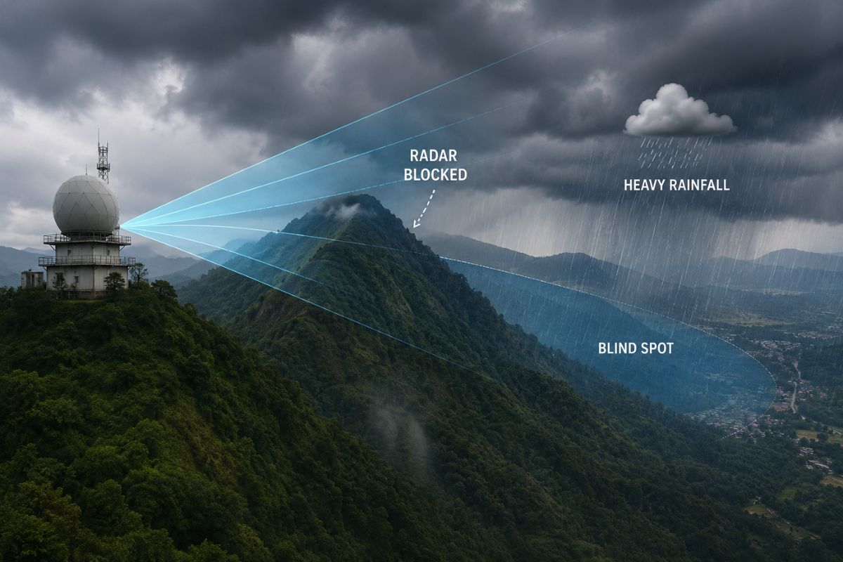
While X-band radars deliver high-resolution short-range scans, their microwave signals travel strictly along a direct line of sight. In complex topography like the Western Ghats mountain range, low-altitude radar scans cannot bend over physical obstacles. By placing the system on the eastern, drier plateau of Pulpally, the radar beam must look west over intervening mountain ridges to monitor the steep, disaster-prone slopes of Meppadi, Vythiri, and Chooralmala.
A spatial terrain analysis by independent researchers reveals that the new system creates critical Wayanad radar blind spots across the district’s most vulnerable western slopes, leaving low-altitude, landslide-triggering precipitation hidden beneath mountain ridges.
Will Mountain Ranges Block Wayanad’s New Pulpally X-Band Weather Radar?
Yes, mountain ridges between eastern Pulpally and the western escarpment physically block the radar’s lowest scan angles, creating blind spots over high-risk landslide zones.
Pulpally rests on the eastern rain-shadow plateau of the district at an elevation of roughly 840 meters above sea level, situated significantly lower than the central ridges separating it from the western border. Conversely, the high-risk landslide zone, comprising Punchirimattom, Mundakkai, Chooralmala, and Attamala, sits tucked against steep western slopes beneath heavy monsoon windward corridors.
According to post-disaster field documentation published by Landslides.org on the Mundakkai event, the 2024 disaster originated on steep forested slopes at coordinates $11^\circ 27′ 52″ \text{N}, 76^\circ 8′ 5″ \text{E}$. Between Pulpally and these origin points lies the rugged terrain of central Wayanad, including the Chembra Peak range, which reaches peak elevations exceeding 2,100 meters.
When a Doppler radar emits its lowest surveillance tilt, typically set at $0.5^\circ$ above the horizon, the beam expands and gains elevation as it travels outward. Over the 35 to 45 kilometers separating Pulpally from the southern and western landslide hotspots, the lowest edge of that microwave beam climbs well above the valley floors. High mountain ridges physically intercept the signal path, preventing radar echoes from returning from the lower atmosphere directly behind the ridge.
Why Does Low-Altitude Radar Coverage Matter for Wayanad Landslide Weather Forecasting?
Low-altitude radar coverage is essential because intense monsoon triggers in the Western Ghats often form as shallow cloudburst cells below 1,500 meters elevation, well beneath the radar beam’s line of sight over western valleys.
In mountain meteorology, shallow convection refers to localised, dense rain clouds that form rapidly between 500 and 1,500 metres above sea level without growing into tall thunderstorm towers. These shallow convection cells frequently dump $200\text{ mm}$ to $300\text{ mm}$ of localized rainfall within a few hours directly onto saturated mountain slopes.
Because the Pulpally radar beam must clear central mountain ridges, its lowest usable scan height over Meppadi and Vythiri floats above 1,500 to 2,000 metres altitude. This altitude gap creates two distinct operational realities:
- High-altitude detection: The system will successfully track large storm systems passing high over the mountains.
- Low-altitude blindness: Intense, localized rain clouds forming below 1,500 meters elevation can develop and drop heavy rain completely underneath the radar beam.
While IMD announcements emphasize a 100-kilometer radius circle of protection, radar coverage over mountainous terrain operates as an inverted cone with an unmonitored shadow zone near the ground.
How Much of Wayanad’s High-Risk Landslide Area Falls Into Blind Spots?
Over 60 percent of Wayanad’s high-susceptibility landslide terrain falls into areas where the Pulpally radar suffers partial or complete low-altitude signal blockage.
The official Landslide Susceptibility Maps from the Geological Survey of India (GSI), distributed by the Kerala State Disaster Management Authority (KSDMA), the state agency overseeing emergency planning, designate the entire western belt of Wayanad as a high-hazard zone.
The GSI maps identify steep slope gradients, heavy regolith depth, and monsoon drainage lines as primary risk factors. Yet, these precise zones sit directly in the radar’s low-altitude shadow. While the system will provide weather data for the eastern plains and neighboring Karnataka border areas, its primary mission, detecting localized triggers above vulnerable western communities, is constrained by physical terrain geometry.
Why Was Pulpally Chosen If Western Ghats Radar Terrain Blockage Exists?
Pulpally was selected because it offers stable land, secure power, and reliable communications infrastructure that remote, weather-exposed mountain peaks lack.
Selecting an operational site for sensitive meteorological equipment requires balancing line-of-sight geometry against severe field constraints:
- Land and Structural Safety: Pazhassi Raja College provided encumbrance-free institutional land with a solid bedrock foundation. Placing delicate radome structures on high western ridges risks structural failure from landslide activity, severe lightning strikes, and extreme monsoon wind speeds.
- Power and Data Links: X-band Doppler radars require continuous grid power and high-speed fibre optic cables to stream gigabytes of raw reflectivity and velocity data to processing centers without interruption. Pulpally connects directly to established utilities that remote ridges lack.
- Regional Monitoring Balance: From a broader state perspective, Pulpally offers a central platform for tracking regional weather systems moving across northern Kerala and southern Karnataka, even if localized terrain shadowing occurs over specific western valleys.
The site choice represents an operational trade-off: it guarantees equipment security and data uptime while accepting coverage limitations over western valleys.
How Can Authorities Fix Wayanad’s Weather Forecasting Gaps?
Authorities can close low-altitude radar blind spots by pairing the main Pulpally installation with micro-radar networks, ground-level rain gauges, and soil monitoring sensors.
To prevent coverage gaps from compromising early warnings, state and central agencies must implement a multi-layered sensor strategy:
- Micro-X-Band Radars: Installing smaller, lower-power micro-radars directly inside key mountain passes, such as Lakkidi or Vythiri, to scan low-altitude valleys beneath the main radar beam.
- High-Density Rain Gauge Clusters: Deploying automated rain gauges every 2 kilometers along high-risk streams to record sudden rainfall surges occurring below the radar horizon.
- Geotechnical Slope Sensors: Placing soil moisture sensors and tiltmeters directly into high-hazard slopes to track ground saturation levels alongside atmospheric data.
The Pulpally Doppler radar adds valuable capacity to Kerala’s weather monitoring network. However, treating it as a complete defense against slope failures ignores Western Ghats geography. Until radar readings are continuously combined with ground-level sensors, communities beneath Wayanad’s western slopes remain exposed to unmonitored low-altitude rain cells.
Frequently Asked Questions
What is an X-band Doppler weather radar?
An X-band Doppler weather radar is a short-range, high-frequency radar system operating on a wavelength of 2.5 to 4 centimeters. It specializes in detecting localized, high-intensity precipitation cells within a 100-kilometer radius, making it ideal for tracking sudden cloudbursts in complex terrain.
Can the new Pulpally radar predict landslides in Meppadi and Chooralmala?
The Pulpally radar cannot predict landslides on its own because it measures rainfall in the atmosphere rather than ground saturation or soil stability. Furthermore, mountain ridges block the radar’s low-altitude beam over Meppadi and Chooralmala, meaning it cannot detect rain cells forming below 1,500 meters elevation in those valleys.
Why does mountain terrain block weather radar signals?
Radar signals travel in straight lines and cannot curve around physical obstacles like hilltops or mountain ranges. When a radar is stationed behind a high mountain ridge, any weather activity occurring lower than the ridge top sits in a “radar shadow” and remains invisible to the scanner.
When will the Pulpally X-band weather radar become operational?
The India Meteorological Department (IMD) plans to commission the Pulpally X-band weather radar at Pazhassi Raja College by December 2026.